
The ever-increasing economic costs and the need to protect the environment increase the importance of precision farming. This technology allows you to collect and monitor detailed information about all parts of a field, which is more efficient than averaging data over the entire area. Previously, this required colossal resources, and therefore it was not available for small farms. In particular, it was necessary to obtain all the information based on which the zoning would be carried out, choose the mechanics of data processing, and determine the optimal number of sites. Today digital technologies allow processing big data, automating the process of their analysis, and visualizing the information received in the appropriate apps. That’s why precision farming increasingly spreads throughout the industry. In this article, we will look at the features of this technology and its advantages over others.
Zone Management
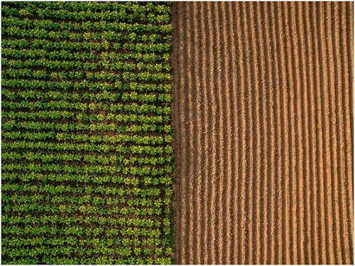
The fact that field areas are unevenly fertile has been known for a long time. However, technologies for measuring and displaying this information have appeared relatively recently. Today, zone management deals with a massive amount of data: yield information, soil types, topographic information, the experience of other producers, as well as various types of images. Among the latter, it is especially worth highlighting satellite data. It allows farmers to analyze the crop state, the entire field, and its sections, and predict potential future changes.
The agricultural zoning map divides a field into similar areas based on the data obtained: according to soil composition, topography, nutrient levels, and even yield during a particular historical period. With such an extensive and comprehensive body of information, farmers can apply:
- variable-rate seeding and fertilizing;
- pest control;
- irrigation solutions;
- lime, if it’s necessary for plants.
At the same time, one zone mapping is not enough for efficient farming. It is necessary to carry out ground checks in real-time, track and analyze actual problems, carefully monitor and evaluate the performance of each field area. Thus, in the end, thriving agriculture requires an integrated approach from producers. Thanks to the available computer technologies, today, such a task is within the power of any agricultural production.
Whole-Field vs. Zone Management
There is a fundamental difference between whole-field and zone management. The first method involves the analysis of the territory as a whole with fixed inputs. In general, this approach allows you to solve management problems. Still, there is a high probability of an increase in economic costs and production losses due to the generalized nature of the input data. Agricultural zone management allows variable data input, optimizing it according to needs. Thus, precision smart farming contributes to increased productivity and profits, energy efficiency, and a better environment.
First, you need to identify all the elements that affect a yield and define zones. Then it would help to process each section separately, while farmers receive information on all the important indicators of this particular field part. The Global Positioning System (GPS), VR applicator, and Variable Rate Technology ensure data accuracy and easy visualization. That is, using specialized applications, farmers receive all data on any mobile device. Moreover, it allows you to control the production process and monitor situation changes in real-time, even from a distance.
Agricultural zone management uses statistical, robust, and non-random parameters. For example, it can be a change in the soil state. At the same time, the response of plants to soil variability can also be used as a reliable yield data indicator. Depending on the size and variability of a field, the number of zones may vary. Usually, three to five sites are enough. The main thing is that each of them is large enough. Otherwise, it will be difficult for an applicator to respond promptly to changes in the norm.
Thus, agricultural zone management is an essential tool for increasing crops. At the moment, it provides farmers with accurate and detailed information about each section of a field, which helps to eliminate problems effectively and control the product quality in real-time. At the same time, the most important task of optimizing the use of natural resources and minimizing damage to the environment is being solved. That is why the relevance of this concept is increasing every year.


